Given the high avalanche risk in the local Rockies due to fresh powder and a dramatic upswing in temperatures, Byron and I decided to play it safe by postponing our original itinerary for the day. In an attempt to find a compromise between my desire for picturesque mountain views and Byron's love of devouring vertical meters, we settled on the ascent up the southwestern side of Sulphur Mountain via Cosmic Ray Road. This route is significantly longer and more physically demanding than the traditional route beneath the Sulphur gondola, but it is also much less crowded (we were the only ones on it all day) and offers beautiful views for the majority of the hike.
Trail Description:
Park in the Cave and Basin parking lot in Banff, and follow the Sundance Canyon pathway until it forks to the left about 10 minutes in. From here we followed a viewless trail through thick pine forest until taking another left turn towards the signed Cosmic Ray Road. This heavily overgrown "road" then climbs at a consistent and fairly steep grade for the remainder of the route while offering spectacular views of the Bow River Valley and a number of recognizable peaks. A couple hours later we arrived at the top of Sulphur Mountain, where I was expecting to be greeted by droves of tourists. However, an Australian employee informed us that the gondola was closed for annual maintenance, and as a result Byron and I had the rare opportunity of exploring the extensive boardwalk network in what felt like somewhat eerie solitude. We only saw a handful of other people up there, all who had hiked up the front side of Sulphur. After a quick lunch of leftover pizza and various other frozen goodies, we returned the way we came and made great time on the equally scenic descent under the golden glow of late-day sun.
 |
| The first few kms of our route looked like this, once forking off the Sundance Canyon trail. |
 |
| On Cosmic Ray Road, gaining elevation and views. |
 |
| Improving views of the Bow River Valley and nearby peaks. |
 |
| Byron breaks trail. |
 |
| Getting higher. Mt Pilot (L), and Mt Cory (R) |

 |
| On the final switchback. Mt Cory (L), Louis (C) and Norquay (R) |
 |
| Deserted Sulphur Mountain boardwalk and gondola station. |
 |
| Byron uses the "Rubber Duck" to hide from the frigid winds. Lake Minnewanka in the distance. |
 |
| Sanson Peak weather station. |
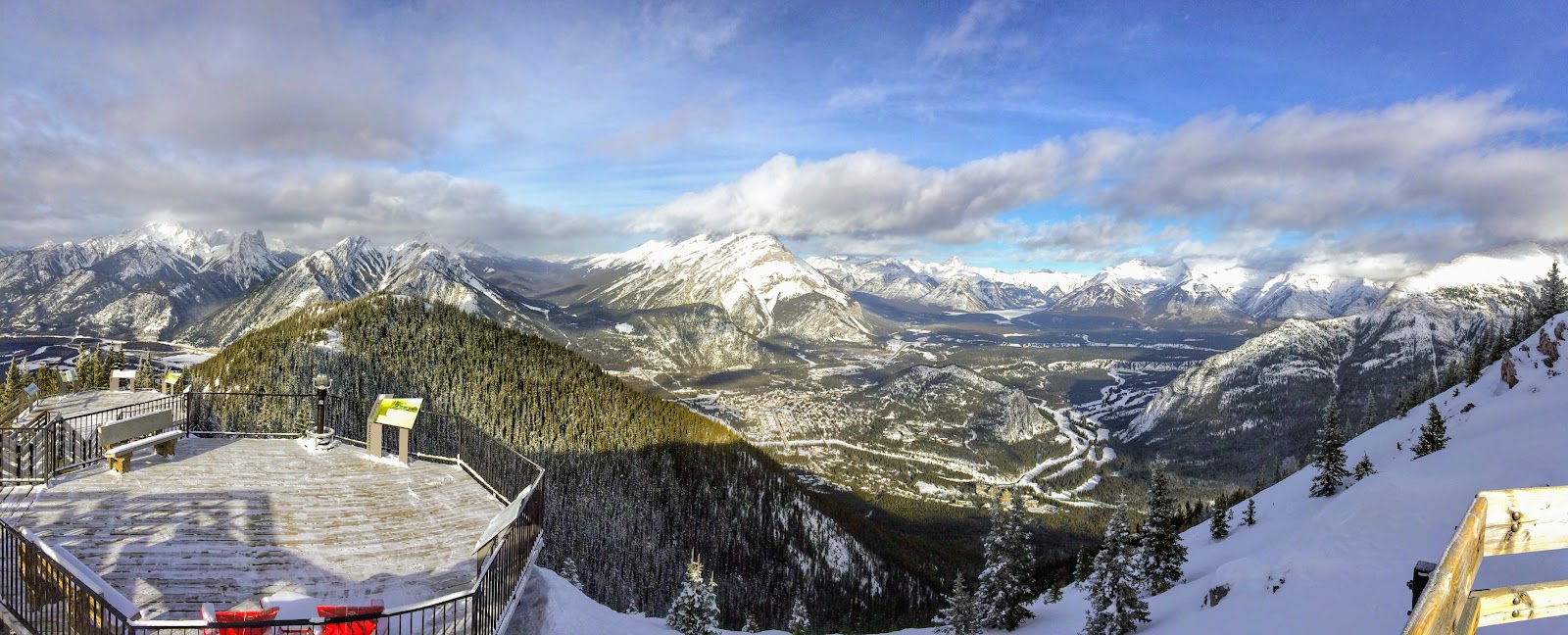
 |
| Sanson Peak panorama, including Banff town and many recognizable features. |
 |
| A closer look at the new Gondola terminal. |
 |
| Heading back down. |
 |
| Byron insisted I make an appearance in this post. |

 |
| Despite hiking on a "road" all day, this was a great trip of both physical challenge and spectacular views! |
Nice view of the "other side" of Sulphur Mountain, since most folks are used to the gondola side. Lucky you, having the place pretty much to yourselves!
ReplyDeleteThanks Mim! It was a little too cold to linger for long, but we definitely enjoyed the scenery and solitude.
ReplyDeleteLovely view!
ReplyDeleteThanks Kay! It was a surprisingly scenic adventure.
ReplyDelete